FREQUENTLY ASKED QUESTIONS

ALPHA
TERRA
- What is Novelgro TERRA ?
- What is Fulvic Acid or Fulvate and Humic Acid or Humate
- What is the difference between Novelgro Terra fulvic acid and humic acid and the natural humus?
- How to enhance or improve potting soil or potting mix, or potting media, compost and bokashi quality with Novelgro TERRA ?
- Can I mix or blend Novelgro TERRA with inorganic fertilizer ?
- How to dry blend Novelgro TERRA with UREA ?
- What is the difference between Novelgro TERRA and other products?
- What is the benefit of Novelgro TERRA application in farming ?
- When and how to apply Novelgro TERRA?
- What plants can use Novelgro TERRA?
- Can Novelgro TERRA be applied together with herbicide?
- How to make Compost Tea?
- Adding Novelgro TERRA to compost pile
ORGANIC NPK
PALM OIL TRUNK INJECTION FERTILIZER
- What is Palm Oil Trunk Injection Fertilizer
- Will the palms die when there is a hole drilled in the trunk?
- How Much is added into each palm?
- Is 65 ml of Trunk Injection Fertilizer sufficient to feed the palms for a month?
- During dry season, do we have to stop applying fertilizer?
- How many type of fertilizer are there in Trunk Injection System?
- How long do you need complete the instalation of the trunk injection system?
- A monthly application sounded very taxing on the worker. In the conventional way, we only apply three to four times a year how could this benefit us?
- How do you know if the trunk injection fertilizer is working on the palms?
SILIKA
- WHAT IS NOVELGRO SILIKA ?
- HOW NOVELGRO SILIKA WORKS ?
- HOW LONG NOVELGRO SILIKA WILL LAST IN PLANT ?
- DOES NOVELGRO SILIKA NEED TO BE REAPPLIED ?
- HOW TO APPLY NOVELGRO SILIKA ?
- WHAT IS THE BENEFIT OF USING NOVELGRO SILIKA ?
- Silicon nutrition benefit to Sugarcane
- EFFICACY TRIAL OF WATER SOLUBLE SILICATE FOR HEALTH, RESISTANCE, AND YIELD IMPROVEMENT OF WETLAND RICE
- SILIKA (TM) AS SILICON NUTRITION FOR HYDROPONICS
BUILDING A GOOD TOPSOIL
PEST CONTROL
POST HARVEST MANAGEMENT
AGRO-METEOROLOGY FOR FARMING BENEFIT
PLANT SPECIFIC APPLICATION
Recomended Dosage
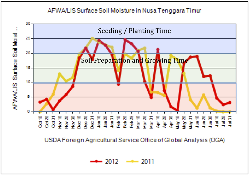
Seeding time is closely related to Surface Soil Moisture. Under a certain surface soil moisture, plant growth condition will be effected.
One of the tools in Crop Explorer is the AFWA Surface Soil Moisture
- 20-25-mm are best for germinating and emerging a new crop, but can halt fieldwork and could damage newly-seeded crops that remain in the wet environment for an extended period of time.
- 15-20-mm of water are normally best for vigorous field activity.
- 10-mm or less will not support seed germination or early growth potentials for a recently emerged crop.
For example, below is the Surface Soil Moisture of Nusa Tenggara Timur Province in Indonesia for year 2011 and 2012. The original graph is devided into 3 Surface Soil Moisture zones, and the planting / seeding zone is depicted in blue zone, which was roughly ranged from mid of December up to mid of March but beware of the Surface soil Moisture reduction at end of January to mid of February. Therefore the seeding time untill the adequate roots formation window shall be in the suitable surface soil moisture range. After roots formation is well formed, plants can start to utilize deeper soil water. And using the 10 days updated data, we can predict the best timing for field seeding, planting and transplanting under rain fed field.


